Discover Your World in 3D, again
June 27th, 2011 | Published in Google Earth
[Cross-posted from the SketchUp blog]
Today, we’re unveiling a totally redesigned Your World in 3D website. If you’re new to geo-modeling -- the term given to creating 3D buildings for Google Earth and Google Maps -- the Your World in 3D website has all the tools and info you’ll need to get up and running quickly. The new website showcases several examples of what fellow modelers are building and will help connect with other geo-modelers around the world.
So that’s the what, here’s the why. Five years ago, Google acquired a Boulder-based startup called @Last Software, which was making waves in the architectural world with their 3D modeling software, SketchUp. Google had an ambitious idea to add a 3D model of every building on the planet to Google Earth, and SketchUp was a tool up to the task. Not only that, by opening SketchUp to a wider audience, users would have the opportunity to help build a virtual mirror of their world.

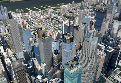
Times Square showcases some of the very first user contributed models
Today, the 3D virtual world is in full bloom: hundreds upon hundreds of villages, towns, and cities have been added to the 3D map representing hundreds of thousands of 3D buildings from every corner of the globe -- truly, a testament to the power of open collaboration.
In the intervening half decade, we’ve introduced several new ways of adding buildings to the 3D map, including Google Building Maker and the Cities in 3D program. And you may have noticed 3D buildings surfacing on Google Maps and Google Maps for mobile as well. With so many different ways of creating and viewing 3D models, we realized we needed a destination that would demystify the process of geo-modeling,
Enter: the new Your World in 3D website. We call the website Your World in 3D because it is you, the user, who is helping build this virtual world, and perhaps more importantly, it is you who is finding innovative and surprising ways of using this data.

Your World in 3D has been redesigned from the ground up
Why geo-model? When asked, most geo-modelers say they do it because geo-modeling is just plain fun, but building your town in 3D can also be a great way to show civic pride and encourage tourism for your town. It can also provide an interactive way to promote your business or contextualize the urban planning. 3D modeling has also been used in crisis response situations as we saw in the grassroots modeling effort that happened after the earthquake in L’Aquila, Italy.
Why create 3D models for Google Earth?
We hope you’ll join us on this mission (and adventure) of building the most comprehensive 3D virtual mirror of planet Earth.
Happy modeling!
Posted by Nicole Drobeck, Geo Community Program Manager
Today, we’re unveiling a totally redesigned Your World in 3D website. If you’re new to geo-modeling -- the term given to creating 3D buildings for Google Earth and Google Maps -- the Your World in 3D website has all the tools and info you’ll need to get up and running quickly. The new website showcases several examples of what fellow modelers are building and will help connect with other geo-modelers around the world.
So that’s the what, here’s the why. Five years ago, Google acquired a Boulder-based startup called @Last Software, which was making waves in the architectural world with their 3D modeling software, SketchUp. Google had an ambitious idea to add a 3D model of every building on the planet to Google Earth, and SketchUp was a tool up to the task. Not only that, by opening SketchUp to a wider audience, users would have the opportunity to help build a virtual mirror of their world.

Today, the 3D virtual world is in full bloom: hundreds upon hundreds of villages, towns, and cities have been added to the 3D map representing hundreds of thousands of 3D buildings from every corner of the globe -- truly, a testament to the power of open collaboration.
In the intervening half decade, we’ve introduced several new ways of adding buildings to the 3D map, including Google Building Maker and the Cities in 3D program. And you may have noticed 3D buildings surfacing on Google Maps and Google Maps for mobile as well. With so many different ways of creating and viewing 3D models, we realized we needed a destination that would demystify the process of geo-modeling,
Enter: the new Your World in 3D website. We call the website Your World in 3D because it is you, the user, who is helping build this virtual world, and perhaps more importantly, it is you who is finding innovative and surprising ways of using this data.

Why geo-model? When asked, most geo-modelers say they do it because geo-modeling is just plain fun, but building your town in 3D can also be a great way to show civic pride and encourage tourism for your town. It can also provide an interactive way to promote your business or contextualize the urban planning. 3D modeling has also been used in crisis response situations as we saw in the grassroots modeling effort that happened after the earthquake in L’Aquila, Italy.
We hope you’ll join us on this mission (and adventure) of building the most comprehensive 3D virtual mirror of planet Earth.
Happy modeling!
Posted by Nicole Drobeck, Geo Community Program Manager