Building a better map of Europe
December 5th, 2012 | Published in Google Blog
More than a billion people use Google Maps each month to find their way around town and around the world. To help these people get exactly the information they need, the Google Maps team works constantly to ensure that the geographic data behind our maps is comprehensive and accurate. As part of this ongoing effort, we’ve just released updated maps for 10 countries and regions in Europe: Andorra, Bulgaria, Estonia, Gibraltar, Hungary, Latvia, Lithuania, Slovakia, Slovenia and Spain.
Today’s update is part of a project called Ground Truth that began in 2008. Through this initiative, we acquire high-quality map data from authoritative sources around the world and then apply a mix of advanced algorithms, supplemental data (including satellite, aerial and Street View imagery), and human input to create a map that corresponds as closely as possible to the real-world facts that you’d find if you were to visit that location.
For example, this update adds a new 70-km section of Bulgaria’s Trakiya motorway, which opened recently to drivers but hasn’t been reflected on most maps of the region until now.

But roads and highways alone don’t define the character of a place, and they aren’t always sufficient to help you get around. So Google Maps also integrates information such as walking paths, ferry lines, building outlines, park boundaries, university campuses and more—providing a richer, more comprehensive and more realistic experience for locals, visitors and armchair travelers alike.
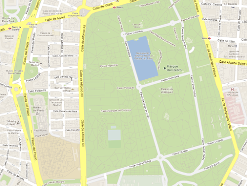
Our new map of Spain, for example, not only shows the famous Museo del Prado and Parque del Retiro in Madrid, but also includes additional building models in surrounding neighborhoods, the well-known “Estanque” (or pond) in the center of the park, and detailed walking paths throughout both the park and the nearby Royal Botanical Gardens.

Of course, the world is always changing, and we want Google Maps to change with it. So when you notice something on the map that needs updating, let us know through the simple “Report a problem” tool in the lower right corner of the map. We’ll make the appropriate changes to the map—often within just a few minutes or hours of reviewing and verifying your feedback! This tool launches today in the 10 places where we’ve updated our maps, and is already available in dozens of other countries around the world.
With today’s release, the maps that we’ve built through our Ground Truth initiative are now available in a total of 40 countries worldwide. To see the progress we’ve made to date, take a look at the image below (click for a full-size version).

We hope today’s launch of more comprehensive and accurate maps of Europe will help you explore amazing places from Barcelona and Budapest to Bratislava and beyond.
Today’s update is part of a project called Ground Truth that began in 2008. Through this initiative, we acquire high-quality map data from authoritative sources around the world and then apply a mix of advanced algorithms, supplemental data (including satellite, aerial and Street View imagery), and human input to create a map that corresponds as closely as possible to the real-world facts that you’d find if you were to visit that location.
For example, this update adds a new 70-km section of Bulgaria’s Trakiya motorway, which opened recently to drivers but hasn’t been reflected on most maps of the region until now.

Explore this area on Google Maps
But roads and highways alone don’t define the character of a place, and they aren’t always sufficient to help you get around. So Google Maps also integrates information such as walking paths, ferry lines, building outlines, park boundaries, university campuses and more—providing a richer, more comprehensive and more realistic experience for locals, visitors and armchair travelers alike.
Our new map of Spain, for example, not only shows the famous Museo del Prado and Parque del Retiro in Madrid, but also includes additional building models in surrounding neighborhoods, the well-known “Estanque” (or pond) in the center of the park, and detailed walking paths throughout both the park and the nearby Royal Botanical Gardens.

Explore this area on Google Maps
Of course, the world is always changing, and we want Google Maps to change with it. So when you notice something on the map that needs updating, let us know through the simple “Report a problem” tool in the lower right corner of the map. We’ll make the appropriate changes to the map—often within just a few minutes or hours of reviewing and verifying your feedback! This tool launches today in the 10 places where we’ve updated our maps, and is already available in dozens of other countries around the world.
With today’s release, the maps that we’ve built through our Ground Truth initiative are now available in a total of 40 countries worldwide. To see the progress we’ve made to date, take a look at the image below (click for a full-size version).

We hope today’s launch of more comprehensive and accurate maps of Europe will help you explore amazing places from Barcelona and Budapest to Bratislava and beyond.