How to write KML like a rock star
July 3rd, 2008 | Published in Google Maps
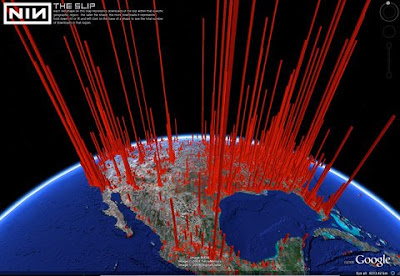
Hi. This is Craig Johnston and Brian Hull of Sudjam, LLC, the company hosting and developing the new online presence for the band Nine Inch Nails. This guest blog entry will cover how we went about creating a Google Earth representation of downloads for NIN's latest album, the slip. We started out with about the first 1.4 million downloads logged (ironically just a subset of the total downloads), and wanted to end up with a dramatic representation of the data set, suitable for the exacting stylistic demands of NIN. Something along these lines:
 We first needed to generate lat/longs, which we did by running the IP addresses logged for each download through the GeoIP® database. The process yielded a high precision set of locations, yet too many to represent as a single data set in Google Earth (we tried). We solved this by grouping the data into histogram-like bins, which we accomplished simply by dropping the precision of the lat/longs when we retrieved them. This took us down to a more acceptable ~40,000 Placemarks, each with a total number of downloads. The next step was to represent the data in a dramatic fashion... or in Google Earth terms, extruding a polygon into space in proportion to the total downloads. We accomplished this easily enough, but then also wanted the download totals for each column to be clickable. We used a solution we found in Jason Birch's blog which involved embedding a point with the polygon section of the Placemark and wrapping them in a MultiGeometry tag, which ended up looking like this:

To avoid the icon clutter, we substituted a 1x1-pixel transparent PNG icon placed in the center of the polygon's base. Finally, we added in a watermark logo and some instructional text using17875 downloads. #base -118.2,34.0,0 1 relativeToGround -118.1,34.1,12512500 -118.3,34.1,12512500 -118.3,33.9,12512500 -118.1,33.9,12512500 -118.1,34.1,12512500